 GeoCities.us
» Yosemite » Lodge
|
GeoCities.us
» Yosemite » Lodge |
Get your FREE home page! |
 |

|
I'm Ron Rivera. I'm a civil engineer with the state highway department in Albuquerque, and my wife Brenda teaches second grade. Last October we called for beds at Phantom Ranch, the lodge at the very bottom of the Grand Canyon, and got two for the first weekend in May. My old roommate from New Mexico State, Jimmy Libby, who adjusts insurance claims in Phoenix now, heard about it and got the last bed in the men's dorm. (The dorms are men's and women's, so Brenda spent the night with nine strangers and says they were better company than we would have been.) The plan was simple. Walk down the South Kaibab Trail on Saturday, sleep at the bottom, walk up the Bright Angel Trail on Sunday. It is the classic way to do it, and now I know why people talk about it the way they do. Friday, April 30: We took the day off and left Albuquerque at 7 in the morning. I-40 to Flagstaff, then north. Arizona doesn't go on daylight saving time, so we got to the South Rim at 12:30 their time after six and a half hours in the car and felt like we'd gotten away with something. Met Jimmy at Mather Campground, walked over to look at the canyon, and went to bed at 8:30 like old men. It got down to 28 degrees that night.
The Numbers I'm an engineer. Of course there's a table.
For comparison, at work we start thinking about truck warning signs when a highway grade gets much past 6 percent. The South Kaibab averages twice that for seven miles, and nobody puts up a sign for your knees. What We Walked Through A ranger at the rim told us the South Kaibab goes down through every layer in the canyon, top to bottom, and it does. Brenda made me learn them. Here they are in order, more or less in their own colors, with the oldest at the bottom.
If You're Going
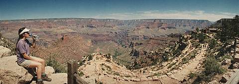
The pictures are from Brenda's camera, two rolls, developed at a drugstore in Albuquerque. I scanned them on the scanner at work on my lunch hours. The panorama print was too wide for the scanner lid, so the ends are cut off a little. Big pictures are around 15K apiece. Hiked the canyon? Planning to? Write me: [email protected]      hikers since May 23, 1999 Last updated September 19, 1999 (added the table Jimmy asked for) |